Exquisite Eratosthenes

Eratosthenes and environs

Eratosthenes and environs
Sketch and Details by Richard Handy

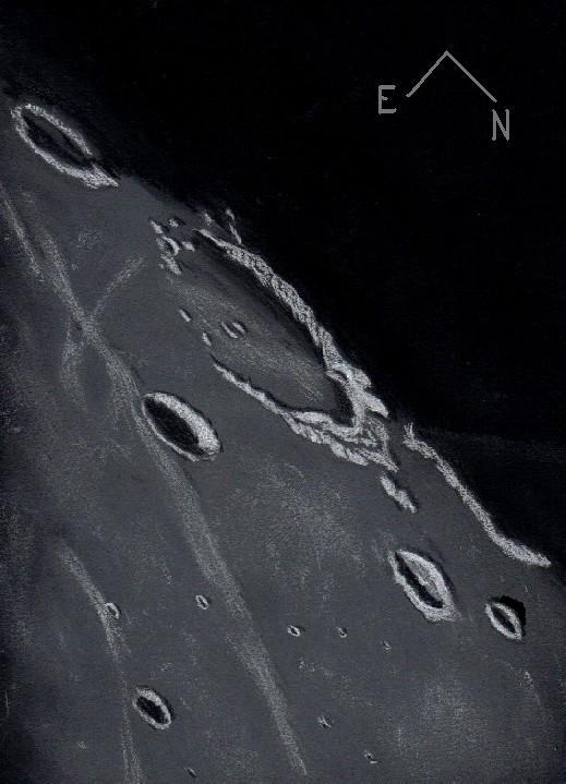
Description: Eratosthenes is the exquisite jewel sitting next to the Hope Diamond of Lady Luna, Copernicus. Consequently, Eratosthenes is often overshadowed by the spectacle of this lunar Juggernaut, however this sparkling gem of a crater and its immediate environment convey some of the major events that dominated the northwestern quadrant of the Moon. From 4.5 billion to 4.2 Billion years ago, a few hundred million years before the period of Heavy Bombardment, the large impactor Gargantuan, first proposed by the British geologist Peter Cadogan, struck the Moon with a force and fury far beyond our comprehension. The possibility that this impact could have, in one single event, reshaped the mean crustal thickness on both sides of the Moon is a staggering thought. Fed by fissures and cracks in the broken crust created by the force of the impact, magmas found easy passage to the basin floor. Over the intervening eons, the great basin formed by that event would eventually fill in with mare lavas to form Oceanus Procellarum. About 3.85 billion years ago, during the period of Late Heavy bombardment (3.8-4.0 by ago) the Moon received another enormous blow to this same northwest quadrant. The impactor, though half the size, formed another great basin, again flooding with mare lavas like Procellarum, to become the beautiful Mare Imbrium. To the east of Eratosthenes, the arcuate sweep of the Montes Apenninus, part of the remnant rim of giant Imbrium, seem to diminish to a few low outcrops as they approach the crater, probably appearing much like a mesa would if you were strolling on the surface. There are a few of these buried massifs on Eratosthenes’ northwestern flanks, although the great circular mountain range disappears in this region only to reappear as the Montes Carpatus to the northwest of Copernicus. There is a wonderful flame-like mountainous formation to the southwest of Eratosthenes, it appears to have been shaped by the fluidized flow fronts from the Imbrium event. Both Copernicus and Eratosthenes are benchmark features, meaning their formations correspond to the beginning of a geological period. Fifty-eight kilometer Eratosthenes was excavated by a 3 km wide impactor some 3.2 billion years ago. It’s rugged walls and terraces show significant scalloping and craterlet battering. The mare around Eratosthenes seemed coated in rays from 93 km Copernicus, which formed 1.1 billion years ago by an impactor 4.5 km in diameter, inaugurating the Copernican period. During this last 1000 million years most complex plant and animal life on Earth evolved.

Sketch details:
Subject: Eratosthenes and environs
Date: 12-28-2006 Start 5:27 UT End 6:50 UT
Lunation: 8.64 days Phase: 68.6 deg Colongitude: 19.8 deg
Illumination: 68.2 % Lib in Lat: -03 deg 24 min Lib in Long.: +01 deg 36 min
Seeing: Terrible most of the session, Antoniadi IV-V, only very occasionally III
Weather: clear
Telescope: 12” Meade SCT f/10
Barlow: 2X Televue
Binoviewer: Williams Optics Bino-P with 1.6X nosepiece
Eyepieces: 20 mm W.O. Plossls
Magnification: 396X
Sketch Medium: White and black Conte’ Crayon on textured black Strathmore paper
Sketch size: 18”x 24”

Eddington: A Mere Shadow of its Former Self

Eddington

Eddington
Sketch and Details by Frank McCabe

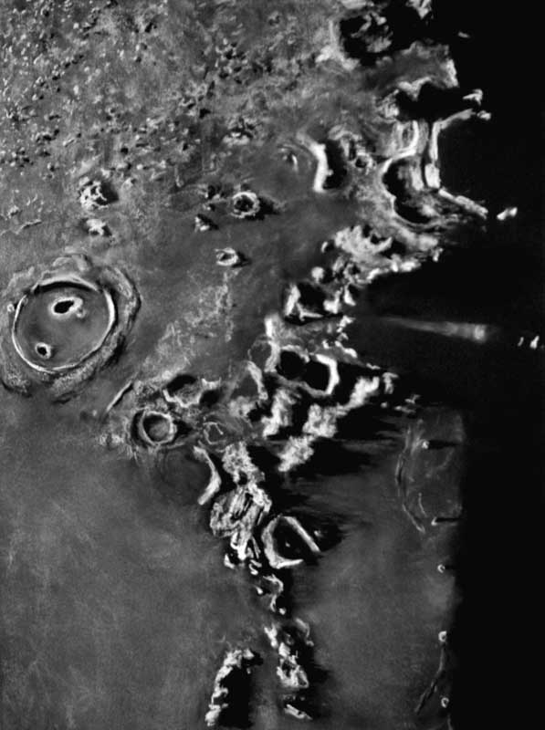
I was disappointed with my previous observation of this region of the Ocean of Storms this past August and this night was my first opportunity to return to this area. On this evening of observing and sketching, 137 kilometer, walled-plain crater remnant Eddington was well positioned and illuminated in the morning sunlight for drawing. The features that identify Eddington as a large crater ruin include the missing southern and eastern rims and the vast flooding of its floor with the mare lavas. Eddington is a Pre-Nectarian period crater which is likely older than 4 billion years. Today its worn appearance still has character. There is a broken arc of rim remains from south to east which gradually climbs from hills to mountains as the rim arc is traced northward. It may no longer be a regal crater, but it makes an excellent bay to the shore of the Ocean of Storms. To the east-southeast of Eddington rests the much younger Eratosthenian period crater Seleucus (44 km.). This is a deep crater at 3 km. and has a bright meandering debris ray from the crater Oblers A (not seen) passing the crater to the east. The Soviet moon probe Luna 13 landed 75 kilometers southeast of this crater. South along the terminator is the crater Krafft (51 km.) which makes an interesting partner to crater Cardanus beyond the sketching region to the south. Two craters are visible north and east of Eddington. These craters are Briggs (37 km.) and Briggs B (25 km.). Both were showing dazzling rims and ramparts in the early sunlight. The lone crater visible across the sketch to the northeast is Imbrian period crater Schiaparelli at 24 kilometers in diameter. This was that perfect lighting I was waiting for to capture this little corner of the Ocean of Storms.

Sketching:

For this sketch I used: black Strathmore 400 Artagain paper, white and black Conte’

pastel pencils and a blending stump. After scanning, Brightness was slightly decreased (-3) and contrast increased (+3) using Microsoft Office Picture Manager.

Telescope: 10 inch f/ 5.7 Dobsonian and 9 mm eyepiece 161x

Date: 6-17-2008, 2:55-3:50 UT

Temperature: 19° C (67° F)

Clear, transparent, calm

Seeing: Antoniadi III

Colongitude 72.7 °

Lunation 13.4 days

Illumination 98 %

Frank McCabe

Rainbow Bay

Bay of Rainbows

Sinus Iridum
Sketch and Details by Frank McCabe

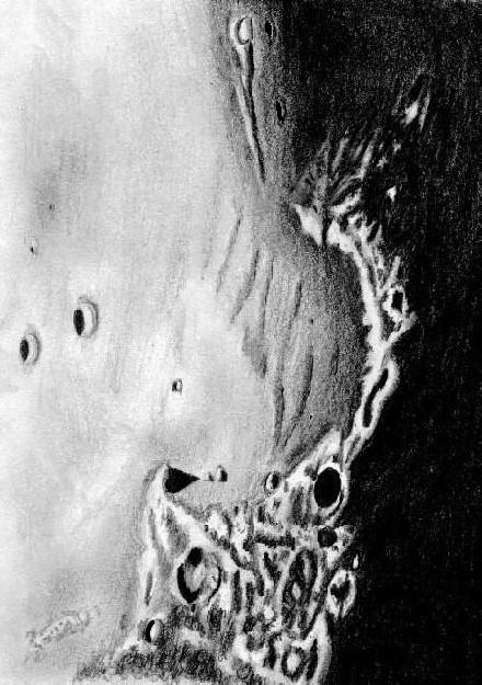
Sinus Iridum (Bay of Rainbows) is one of the more attractive impact regions of the lunar moonscape under grazing illumination. The northern and western rim of this impact basin is composed of the rugged Jura mountain range from Cape LaPlace in the northeast to Cape Heraclides (the Moon Maiden) to the west. The bay reaches across a central distance of 260 kilometers. The entire southern portion of the crater rim is not seen for it is covered by the Mare Imbrium lava flows. First the massive impact that created Mare Imbrium about 3.8 billion years ago occurred. That event was followed by the smaller basin creating impact that left the large “crater Iridium” and subsequent events that buried its southern rim under lava flows some 3.3 billion years ago. Some geologists have suggested a seismic event before the lava flows aided in lowering the southern rim (see C.A Wood, The Modern Moon, p. 37).

One of the first sketches featuring Sinus Iridium in a telescopic view was done by Giovanni Cassini in 1679. In his drawing the Moon Maiden is featured. In my drawing Promontorium Heraclides (Moon Maiden) is seen at the upper right. Beyond this cape is a frozen wave of lava known as Dorsum Hein at the top center of the sketch. Following the arc of the sunlit Jura range, your eye arrives at the large shadowed floor of crater Bianchini (39km.) just beyond the half way point to Promontorium LaPlace (Cape LaPlace). Note the slumping of rim debris out into the bay from crater Bianchini. On to Cape LaPlace there is a tall mastiff at the cape that is casting a large triangular shadow that created a pleasing and eye catching view at the telescope ocular. Out beyond the reaches of the Bay of Rainbows are a pair of 20 km. diameter craters; Le Verrier is the slightly smaller one on the left and the other one is Helicon. This is a fascinating region of the moon to explore with a telescope and great fun to try and capture on paper.

Sketching

For this sketch I used: White CPP sketching paper, 9”x 12”, Numbers 2H, B and 4B graphite pencils, a blending stump, plastic eraser and an eraser shield. After scanning, Brightness was slightly decreased (-3) and contrast increased (+3) using Microsoft Office Picture Manager.

Telescope: 10 inch f/ 5.7 Dobsonian and 9mm eyepiece 161x
Date: 6-14-2008 1:30 – 2:42 UT
Temperature: 24° C (77° F)
clear, breezy
Seeing: Antoniadi IV
Co-longitude: 34.9°
Lunation: 10.26 days
Illumination: 81.5 %
Phase: 50.9°
Observing Location: +41°37′ +87° 47′

Frank McCabe

The Highlands Between Grimaldi and Mersenius

Highlands Between Grimaldi and Mersenius

Highlands Between Grimaldi and Mersenius
Sketch and Commentary by Frank McCabe

With the moon at nearly full phase, the sunrise illumination was approaching the western limb on this evening of observing and sketching. The region I focused in on includes the highlands just beyond the southwestern portion of Oceanus Procellarum between the Grimaldi basin and crater Mersenius. Both of these features are outside the boundaries of this sketch. Normally in this light I can hold the linear Rille Sirsalis in view continuously, but on this night it was visible only intermittently. Twin craters Sirsalis (43 km.) and Sirsalis A (49 km.) were clearly visible with their bright rims and dark shadowed floors. It is clear from some light reaching the floor of Sirsalis A that Siralis is the deeper of the two.
Lava flooded Billy, an Imbrium crater at 46 kilometers is separated from slightly younger crater Hansteen (45 km.) by Mons Hansteen. Beyond these features the remains of Siralis E a ghostly 72 kilometer crater remnant was visible in the morning sunlight.

Sketching:

For this sketch I used: black Strathmore 400 Artagain paper, 8”x 11”, white and black Conte’pastel pencils and a blending stump. Brightness was slightly decreased (-5) and contrast increased (+6) after scanning using Microsoft Office Picture Manager.

Telescope: 10 inch f/5.7 Dobsonian and 9mm eyepiece 161x
Date: 3-20-2008 4:50 – 6:00 UT
Temperature: -2°C (28°F)
clear, calm
Seeing: Antoniadi III
Co longitude: 66.9°
Lunation: 12.5 days
Illumination: 97.5 %
Phase: 18.4°
Observing Location: +41°37′ +87° 47′

Frank McCabe

Alexander’s Waning Ray

Alexander’s Waning Ray

Alexander’s Waning Ray
By Richard Handy

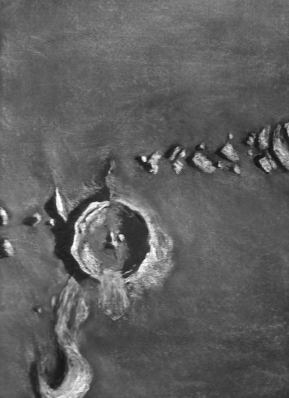
When the waning Moon brings long spires of deep shadows to the mountains and scarps that line the western shores of Mare Imbrium, the peaks of the Montes Caucasus become beacons of bright white light, radiant and dazzling in the last rays of late lunar afternoon sun. This arcuate, rugged range, a remnant of the multi-basin rings raised by the titantic Imbrium impact, reach a lofty 6000 meters in elevation above Mare Imbrium and Serenitatis today. The strait that separates the Caucasus and the Montes Apenninus is probably the result of the previous Serenitatis impact. The collision excavated a large section of crustal material at the eventual and almost tangental intersection of these two great lunar basins, so here no mountains nor hills were lifted high enough to survive the much later inundation by mare basalts. The dark parabola of shadowed Alexander is illuminated by a single, slim dagger of light. Was this ancient Pre-Imbrium 82 km crater the result of an oblique impact? The heavy fill of ejecta from the Imbrium or Serenitatis events and the remainders of its sparse and broken ramparts make interpretation difficult, still it’s general elliptical depression begs this question. Between the Montes Caucasus and the Montes Alpes to the northeast lies Cassini with it’s smooth appearing glacis. This Lower Imbrium crater almost looks to have impacted into a semi-liquid layer of basalt, so soft and thin is the appearance of it’s glacis. To the northeast of Cassini, The Montes Alpes, a great blocky wedge composed of lineated chunks of broken regolith, is scattered radially from the center of Imbrium, evidence of the sheer power of an explosion that lifted up mountain ranges and tossed aside blocks of lunar crust the size of stadiums hundreds of kilometers from it’s center. Beyond the field of view of this sketch, the Vallis Alpes confirms the readjustment that occcured millions of years after the Imbrium event, as large sections of crust pulled apart under the stresses of sublithospheric flows.

Sketch details:

Subject: Alexander’s Waning Ray Rukl: 12, 13,
Time: 9:50 UT to 10:17 UT Date: December 30, 2007
Seeing: Antoniadi III -IV Weather: clear and 10 mph breeze
Lunation: 20.68 days
Colongitude: 164.0 deg.
Illumination: 58.9%
Lib. in Lat.: +03 deg. 30 min.
Lib. in Long.: +06 deg. 29 min.
Phase: 280.2 deg.
Telescope: 12″ Meade SCT f/10
Binoviewer: W.O. Bino-P with 1.6X nosepiece
45 deg. W.O. erect image diagonal
Eyepieces: 18mm W.O. Plossls
Magnification: 271X
Sketch Medium: White and gray pastels on Strathmore black Artagain paper
Sketch size: 18″ X 24″

Semiannual Lunar Ritual

Vallis Schröteri

Vallis Schröteri and environs
By Jeremy Perez

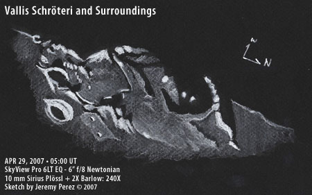
And so, in the spirit of completing one Lunar sketch and observation every 6 months or so, I present Vallis Schröteri. On the night I made this observation, I was very impressed by the rugged terrain in the vicinity of this sinuous rille. The whole area looked like a badly skinned knee in merciful shades of gray. Although Vallis Schröteri was the celebrity, a few other features played staring roles. Mons Herodotus shone brilliantly while the craters Herodotus and Aristarchus stared out like spectacled eyes with the teardrop of Väisälä glistening on the burnished cheek of a nearby highland. Further to the north, Montes Agricola embraced the region like the tip of a rattlesnake’s tail.

There was so much to observe and sketch, I couldn’t possibly capture it all. I did learn from my previous attempts at white on black Conté sketching and went for a larger illustration. This sketch was prepared on a 9″ x 12″ sheet of black Canson Mi Tientes pastel paper. I used a blending stump to smooth the pastel where appropriate and to build up brighter tones. The brightest rims are straight attacks with the Conté pencil. The sketch took about 45 minutes at the eyepiece with another 15 minutes of additional touch-up indoors. White on black sketching is really a great way to tackle the moon–especially the terminator. I hope to keep working at it when time permits. I’ll still be using pencil and charcoal, but it’s nice to have this method accessible when I want it.

Object Information:

Vallis Schröteri is the largest sinuous valley on the Moon. Although hidden in shadow in my sketch, this valley makes its start at a 6 km diameter crater just north of Herodotus crater and widens to 10 km. This area is sometimes referred to as the Cobra’s head. It then winds 160 km and narrows to 500 m at it’s end. The rille is likely the result of volcanic activity as a lava flow carved its winding path through the landscape. Aristarchus is a remarkably bright crater with a pronounced ray system. It is 40 km in diameter and is believed to be a relatively young 450 million years old.

Subject Vallis Schröteri and Surroundings
Classification Sinuous Valley, Craters and Mountains
Position West
Phase/Age 11.7 Days
Size* Vallis Schröteri: 160 km length x 1000 m depth (max)
Herodotus: 35 km dia
Aristarchus: 40 km dia x 3000 m depth
Väisälä: 8 km dia
Dorsum Niggli: 50 km length
Montes Agricola: 160 km length
Mons Herodotus: 5 km dia
 
Date/Time April 28, 2007, 10:00 PM MST (April 29, 2007, 05:00 UT)
Observing Loc. Flagstaff, AZ – Home
Instrument Orion SVP 6LT Reflector (150 mm dia./1200 mm F/L)
Eyepieces/Mag. 10 mm + 2X Barlow (240X)
Conditions Partly cloudy, calm
Seeing Ant. III
Sources Atlas of the Moon by Antonín Rükl 2004; Observing the Moon by Gerald North 2000.
* Based on published data.

Rugged, Majestic, and Arcuate

Lunar Mountain Range


The Montes Apenninus
By Eric Graff

Lunar Mountain Range

Parks Astrolight EQ6 * 6″ f/6 Newtonian Reflector

6mm Parks Kellner + 4x Barlow * 600x, ~4′ Field of View

19 October 2007 * 01:35-03:50 UT

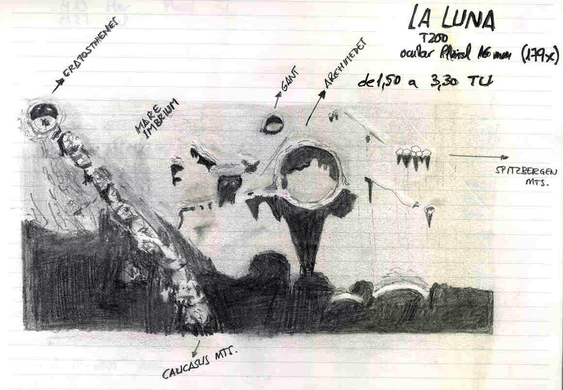
The largest lunar mountain range; the majestic Montes Apenninus extend 600
kilometers around the south preceding  (sp) rim of Mare Imbrium.  The highest peaks
exceed 5000 meters.  The Apollo 15 mission landed at the foot of this range.

This observation shows the north-preceding (np) end of this range extending from the
lunar terminator at the first quarter phase (7-day-old moon).  The prominent crater
near the center of the field of view is 22 kilometer-wide Conon, noted for its sharp
rim.  Prominent peaks of the range shown here include Mons Ampère (near the sf edge
of the field of view), Mons Huygens (5600 m), Mons Bradley (5000 m, very prominent,
following Conon), an apparently nameless peak north of Conon, and finally Mons
Hadley Delta and Mons Hadley (4500 m) at the np end of the range, which terminates
in Promontorium Fresnel.

An extensive range of foothills precedes the Apennines, while the following side
drops precipitously toward the floor of Mare Imbrium.  A series of six small,
elongated hills runs parallel to the following side of the range.  Many of the
foothills on the gently-sloping preceding side are arranged in gently curving
parallel chains sweeping southward from the higher slopes, particularly in the area
south of Conon.  This “curious” uniformity of orientation is likely the result of
shock fractures induced by the Imbrium asteroid impact.

Deep in shadow, at the nf edge of the field of view are the walls of Archimedes;
Autolycus rests on the northern edge of the field, also heavily shadowed.

A Tranquil and Serene Tapestry

Mare Serenatatis and Tranquillatis

Mare Serenitatis and Mare Tranquillitatis
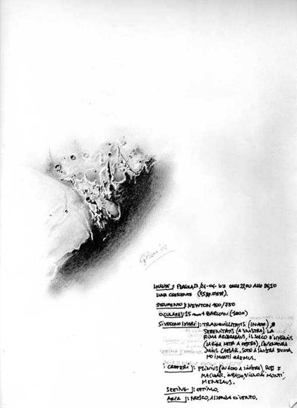
By Giorgio Bonacorsi

 Hello, my name is Giorgio Bonacorsi, I live in little town named Pergola, in Marche, center Italy. My night sky is good, I live near mountain Catria(1702m). My observation site are at 3-4 minutes from home and are at 400-500 m of altitude. I go there for my sketches of galaxy and other object of deep sky,but also behind my home I have a good sky, principally for Moon, planets and comets. My instruments are: Newtonian telescope 15cm 750f, acromatic80/1000, maksutov-cassegrain 110/1035, 16×80 binocular.

The Great Black Lake of Johannes Hevelius

Crater Plato

Plato
By Frank McCabe

   
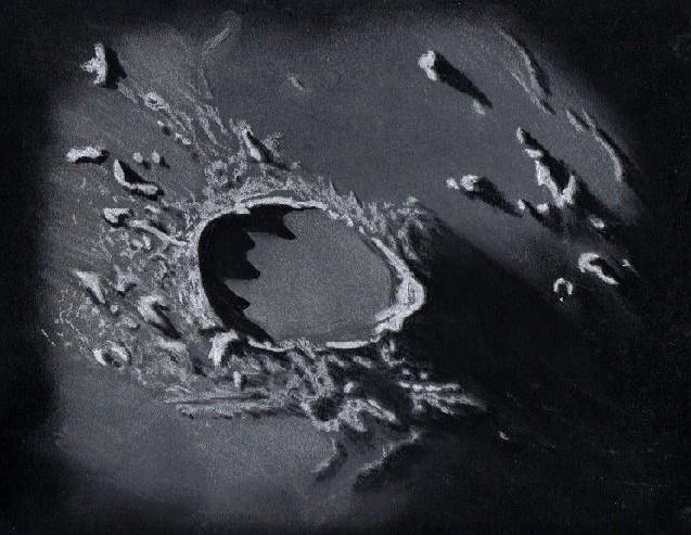
  After 3 weeks of cloudy nights I was anxious to get out in the moonlight to attempt some moon and Mars observing. The seeing was too poor for a good view of Mars but with the moon just past first quarter many targets were available for examination and sketching.
  
  The selected region along the terminator for this sketch is walled plain crater Plato. Since I am viewing through a Newtonian telescope the drawing is inverted from the direct view. Plato is a beautiful 100 kilometer diameter crater with a dark, flat, thick, lava covered floor.  Normally in average seeing four of the craterlets across the dark flat floor are visible but not on this night with the poor seeing conditions. Shadows of peaks created by the 2 kilometer high irregular eastern crater rim stood out across the crater floor.  The enormous amount of lava flooding the crater floor has completely buried the central peaks. Although the impacting rock that created Plato more than three billion years ago came later than the much larger Imbrium impactor, the lava flooding of the region was subsequent to both events. The triangular massif on the western rim (right side) of the crater was difficult to see clearly because of the poor seeing. To the southwest of Plato across the Imbrium basin floor stands the sentinel peak Pico and on further towards the terminator westward the Teneriffe peaks. A small portion of Mare Frigoris can be seen north (below) of crater Plato.
  
  
  Sketching:

For this sketch I used: black Strathmore 400 Artagain paper, 12”x 9”, white and
black Conte’pastel pencils and a blending stump. Brightness was slightly decreased
after scanning.

Telescope: 10 inch f/5.7 Dobsonian and 9mm eyepiece 161x
Date: 12-16-2007 2:30-4:00 UT
Temperature: -6°C (21°F)
partly cloudy, windy
Seeing: Antoniadi IV
Co longitude: 15°
Lunation: 8.4 days
Illumination: 58 %

Frank McCabe