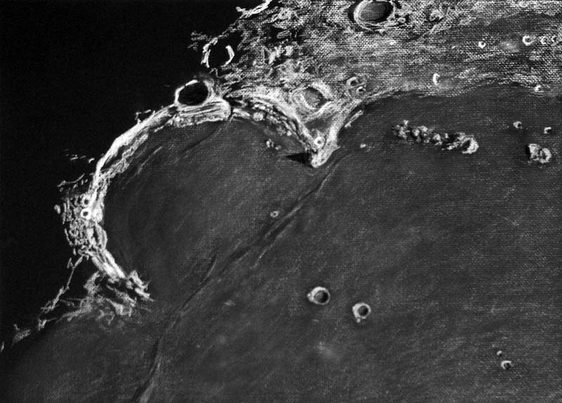
Prismatic Bay

Prismatic Bay

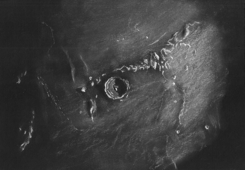
Sinus Iridum, The Bay of Rainbows
Sketch and Details by Tamás Ábrahám

Sinus Iridum

During the observation and sketching the inner part of the bay was shaded, but the Montes Jura with Crater Bianchini was illuminated by the Sun.
The Crater Maupertuis was visible well. Seeing was not so good this night.

Details
Date: August 30, 2009
Equipment: 8 inch f/5 Newtonian reflector with 4 mm SW Planetary eyepiece
Location: Zsámbék, Hungary
Technique: black paper, white and black pencils

Tamás Ábrahám

Together with Plato

Together with Plato

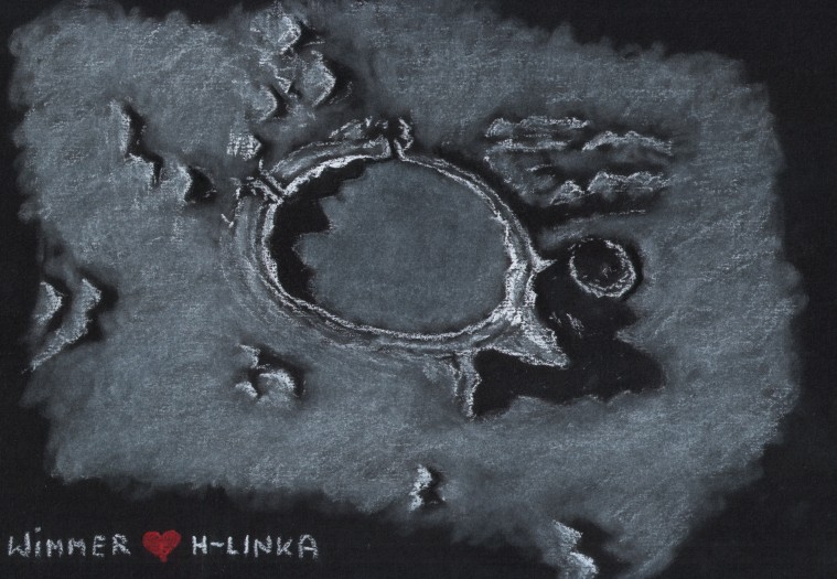
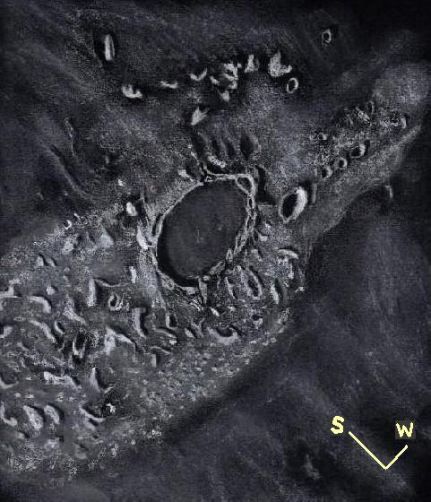
The Lunar Crater Plato
Sketch by Aleksander Cieśla & Anna Pawliczak, details by Aleksander Cieśla

Hello!
This is Plato crater. Once night I and my fiancee, Anna, first time we sketch together. Anna have no sketching skills yet, but She has helped me with lights and shadows on this sketch.

Object: Moon. Plato crater.
Scope: Schmidt-Cassegrain 5″ with Antares SW 7,4mm & barlow lens 1,6x
Place: Poland, Wrocław – near city center
Weather: Very good. Seeing: 9/10. Transparency: 8/10 but Light Pollution
Date: 3rd April 2009
Technigue: White pastels on black paper.

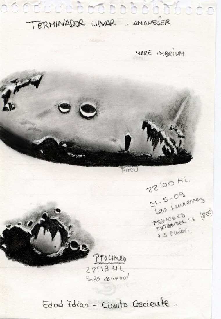
Sunrise on the Moon: Gates of Mare Imbrium and Ptolemaeus

Gates of Imbrium and Ptolemaeus

Gates of Mare Imbrium and Ptolemaeus
Sketch and Details by Leonor Ana Hernández

Object name: oriental region of Mare Imbrium and Ptolemaeus crater
Object Type: Lunar Crater and Maria

The last sunday 31th we could point the telescope to the moon in a beautiful place called “Las Inviernas” Guadalajara, Spain. The moon was just on the seventh day and stood high on the beautiful background of blue sky. I looked through the telescope and I was fascinated by the beauty of the image it shows: “it was dawning at the gates of the east of Mare Imbrium”…

Leonor Ana

Cassini, Aristillus and Autolycus with the Caucasians

Cassini Aristillus Autolycus Caucasins

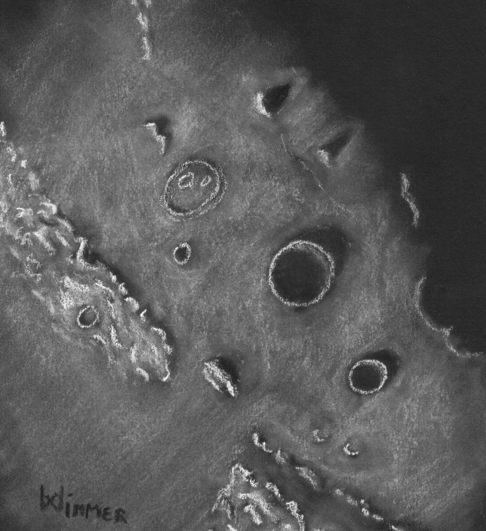
Cassini, Aristillus, Autolycus craters and part of the Caucasus Mountains.
Sketch and Details by Aleksander Cieśla

Hello. This is my next sketch of the Lunar surface. On this sketch: Cassini, Aristillus, Autolycus craters and part of the Caucasus Mountains.

Object: Moon. Cassini, Aristillus, Autolycus craters and Caucasus Montes
Scope: Schmidt-Cassegrain 5” + barlow 2x + Antares SW 7,4mm
Magnification: about 338x
Place: Poland, Wroclaw – near city center
Weather: Not good. Seeing 5/10. Light Pollution. Light clouds.
Date: 2 February 2009
Technique: Black & White pastels on black paper
Tooling: N/A

Sharp Shadows Over the Caucasian Mountains

Sharp Shadows

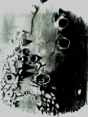
The Caucasian Mountains of the Moon
Sketch and Details by Krzysztof Jastrzębski “Jarzbi”

Hi.
This is my first astronomy sketch made with pencils. It’s too hard as
for the first time.
Object Name:
* Object Type (Moon Craters)
* Location (Skawina City in Poland)
* Date (04 January 2009)
* Equipment: Synta 8” Dob, Eyepice LV 5.

Greetings,
Krzysztof Jastrzebski (Jarzbi)

Eratosthenes and the Apennines

Eratosthenes

Eratosthenes Crater and the Montes Apennius
Sketch and Details by Aleksander Cieśla

Eratosthenes crater and the Apennines Mountains on the Moon’s surface.

Object: Moon – Eratosthenes Crater
Scope: Schmidt-Cassegrain 5” + Speers-Waler 7,4mm + barlow 1,6x
Filter: Moon&SkyGlow
Place: Poland, Wroclaw – near city center
Weather: Good. Seeing 7/10. Light Pollution.
Date: 6-7 January 2009
Technique: White pastel crayons on black paper
Tooling: N/A

The Bay of Rainbows

Sinus Iridum

Sinus Iridum
Sketch and Details by Richard Handy

Less than a several hundred thousand years after the impact that formed the Imbrium basin about 3.8 billion years ago, the 260 km Upper Imbrian crater formed that would eventually become known to observers as Sinus Iridum, the poetically named Bay of Rainbows. In a blindingly intense blast lasting less than a couple of seconds, the roughly 13 km Iridum asteriod gouged out a section of one of the ejecta rings that surrounded the Imbrium basin, scattering a rubbly circular lens of debris around the crater. It’s floor was lower in depth to the south, where it intersected the plate shaped lowlands of the basin. Huge chuncks of ejecta covered or partially obliterated the older craters that had survived the Imbrium event, giving Nectarian aged 48 km Maupertuis on it’s northeast slopes an odd rhomboidal shape. Thirty seven km Lower Imbrium La Condamine to the north seems to have faired a little better, partially filled with Iridum ejecta. 24 km Bouguer to its west is the the most recent, of Copernician age. To the northwest it pushed up the rim creating the Jura mountains, in places 6000 meters high. Even though the Imbrium basin had been flooding for a few hundred thousand years, and the mare basalts had not yet reached the lower elevations of the southern rim of the Iridum crater, it seems likely that Iridum’s floor had already been weeping a slow flow of lava from fissures that had been opened up by the force of the fiery impact. Still it would be close to half a billion years before the Imbrium flows began to erode the southern peaks and cascade down the slopes to completely cover the crater floor. As the lower southern floor began to subside from the load of dense basalt, the whole southern rim section may have suffered a series of catastrophic slides further down into the Imbrium basin, producing the clean separation at the 2600 meter high Promontorium Laplace, the eastern cape. Now only the sinuous dorsae near the craterlet Laplace A mark the rim’s southern boundry. To the west, the Promontorium Heraclides, Cassini’s aptly named “Moon Maiden”, reaches a height of 1700 meters, yet the western cape seems to taper to the southwest, blending rather smoothly into the mare. Along with its slow liquid inundation, Iridum was struck by several small impacts, most notably 39 km Upper Imbrian Bianchini which apparently caused a section of the northern rim to collapse, creating a talus of regolith beneath it’s southern rampart as a result of the seismic shock imparted so close to the rim of Iridum. Beyond the capes to the southwest are the 26 km Imbrium aged crater Helicon and it’s smaller companion, 20 km Eratosthenian Le Verrier. Out on the mare, to the west of Promontorium Laplace, is Montes Recti, a rectangular group of mountains 94 km long x 12 km wide, at 1800 meters, towering over the surrounding somber lava plains.

Sketch details:

Subject: Sinus Iridum #14 of L100 Rukl: 2, 3, 10 , 11
Time: 4:47 UT till 6:10 UT Date: July 25, 2007
Seeing: Antoniadi III -II Weather: clear and calm
Lunation: 10.7 days
Colongitude: 35.8 deg.
Illumination: 76.8%
Lib. in Lat.: +07 deg. 31 min.
Lib. in Long.: -03 deg. 28 min.
Phase: 57.6 deg.
Telescope: 12″ Meade SCT f/10
Binoviewer: W.O. Bino-P with 1.6X nosepiece
45 deg. W.O. erect image diagonal
Eyepieces: 18mm W.O. Plossls
Magnification: 271X
Sketch Medium: White and black Conte’ crayon on black textured Strathmore paper
Sketch size: 18″ X 24″
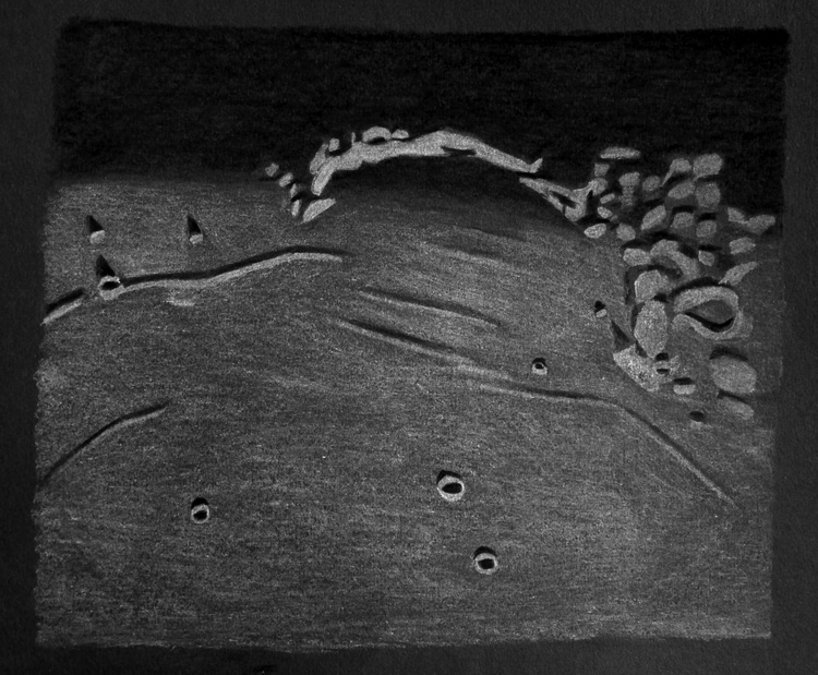
Crater Plato and Environs

Plato

Plato and Environs
Sketch and Details by Frank McCabe

One of the more famous features of the lunar surface is the walled plain crater Plato. This 100 kilometer crater was formed on the blocks of ejecta or the debris field (lunar Alps) of the Mare Imbrian basin forming event and it preceded the lava upwelling that flooded the floor of the crater and then the maria. Beyond the highland rise of the crater to the north is Mare Frigoris. To the west of the crater is Plato A a 22 km. crater beyond the ramparts of Plato. Just on to the smooth Imbrian lava to the south are the Teneriffe Mountains including Mount Pico at the east end of the chain. A portion of Rimae Plato was visible intermittently in among the rugged mountain bases of the Alps as seeing briefly reached average value now and again. The central peaks present at the time of the Plato impact are buried under 2 kilometer of lava and only small craterlets can be seen on the floor. Two of these were in and out of visibility as I drew this sketch. The rim on the shadowed side of the crater has irregular peaks that reach to 2.6 km. above the crater floor. At times of lower sun angles the irregular peaks cast long shadows that allow you to locate these summits.
In the years of the 17th century after the invention of the telescope, crater Plato changed names three times. In 1645 it was named Lacus Panciroli by Michael van Langren and in 1647 Johannes Hevelius named it Lacus Niger Major and finally Fr. John Baptist Riccioli in 1651 gave it the name we call it to this day.
If you have a telescope take a look at the crater floor and watch it change in brightness as we approach and then go past full moon. The moon is not light pollution it is a rewarding astronomical target.

Sketching:

For this sketch I used: black Strathmore 400 Artagain paper 10”x12”, white and black Conte’ pastel pencils and a blending stump. After scanning, Brightness was decreased (-2) and contrast increased (+2) using Microsoft Office Picture Manager.

Telescope: 10 inch f/ 5.7 Dobsonian and 9 mm eyepiece 161x
Date: 9-10-2008, 1:15 – 2:30 UT
Temperature: 15° C (60° F)
clear, calm
Seeing: Antoniadi III
Colongitude 29.6 °
Lunation 10.2 days
Illumination 72.7 %

Frank McCabe

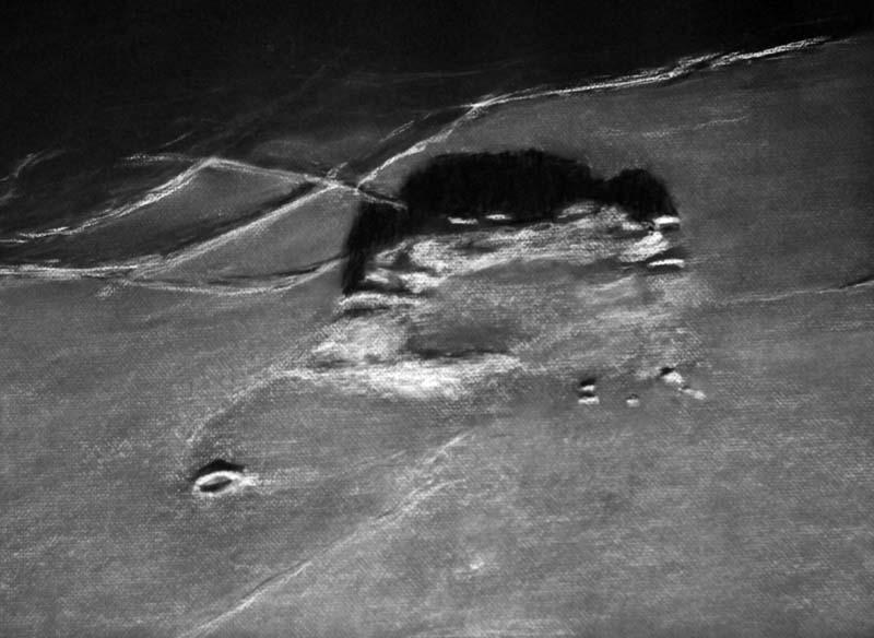
The mysteries of Mons Rumker

Mons Rumker

Mons Rumker
Sketch and Details by Richard Handy

Mons Rumker sits in isolation on the dark basalts of northwest Oceanus Procellarum like a lonely sentinel on the edge of some vast undiscovered wilderness. The Rumker Hills dome complex, situated on the western flank of the Aristarchus Plateau, lies on the top of a local swelling that is about 140 km in diameter. It is composed of a remarkable set of about a dozen volcanic domes and low mounds, which are scattered in a rough semi-circular plateau approximately 70 km in diameter. The surficial domes apparently overlay preexisting low domes so that the elevated northwest sections have a pancake like appearance. Despite the long shadows when viewed close to the terminator, nowhere do these domes rise much above 500 meters in elevation from the mean surface of the mare. A central depression to the southeast of the domed crescent displays a strange dichotomy between its darker and lighter floor that is very reminiscent of areas on the Moon that have pyroclastic deposits. The mysteries of Rumker are manifold: why is this the only such layered dome field on the surface of the Moon? Why is located here? Does it predate the mare lavas or is it the representative of the last vestiges of differentiated magmas that ended the mare sequences in this area? Is the central depression part of a preexisting separate domain or were both aspects, both domes and depression deposits, created over the same period of time?

Sketch details

Subject: Mons Rumker and environs Rukl: 8
Date: 3-31-07
Session Start 8:03 UT End 9.48 UT
Seeing: Antoniadi II-III Weather clear
Lunation 1042, 12.3 days Phase: 25.2 deg Illumination 95.2%
Colongitude: 60.7 deg
Lib in Lat: +00 deg 05 min Lib. in Long: +04 deg 04 min
Telescope: Meade 12” SCT f/10
Binoviewer: W.O. Bino –P with 1.6X nosepiece
Eyepieces: 12.4 mm Meade Super Plossls
Magnification: 393X
Sketch medium: White Conte’ Crayon on black textured Strathmore paper
Sketch size: 18” x 24”

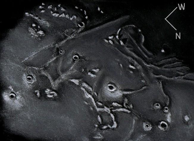
Southeastern Ocean of Storms

southern Oceanus Procellarum

Southern Oceanus Procellarum
Sketch and Details by Frank McCabe

Shortly after sunset I turned my telescope in the direction of the moon and was planning to sketch the crater Longomontanus. However that all changed when I spotted a ghostly, mostly buried crater in southern Oceanus Procellarum right at the terminator. For June 10, 2006 at C. Wood’s site – LPOD, you can find a photo of this region of the moon. Superimposed over this crater are a series of dorsa (ridges) known as Dorsa Euclides F. The lava in this region is not quite thick enough to cover all the evidence that this unnamed crater existed. To the east the 12 kilometer Copernician period crater surrounded by bright ejecta at the center of the sketch is Euclides. Just to the east of this crater are the Riphaeus mountains. North of the mountains you will see four of the Lansberg craters with the largest being Lansberg D (11 km.).
The two small Eratosthenian craters at the far left side of the sketch are Kuiper and Eppinger both at about 6 km. in size.
I love these views that inspire us to capture them with a sketch.

Sketching:

For this sketch I used: black Strathmore 400 Artagain paper 9”x12”, white and black Conte’ pastel pencils and a blending stump. After scanning, Brightness was decreased (-5) and contrast increased (+3) using Microsoft Office Picture Manager.

Telescope: 18 inch f/ 5 Dobsonian and 12 mm eyepiece 167x
Date: 8-12-2008, 1:35 – 3:05 UT
Temperature: 21° C (71° F)
Partly cloudy, hazy, calm
Seeing: Antoniadi II – III
Colongitude 35.8 °
Lunation 10.6 days
Illumination 78.9 %

Frank McCabe