Crater Mersenius

Crater Mersenius

Crater Mersenius
Sketch and Details by Frank McCabe

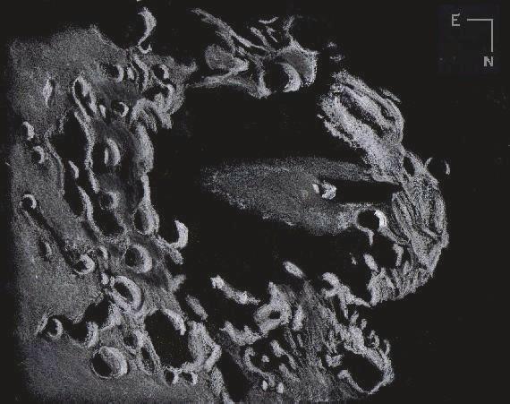
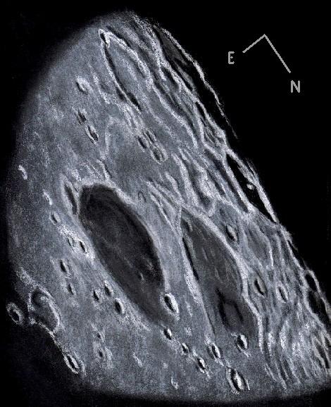
Mersenius is an 84 kilometer diameter floor fractured crater just to the west of Mare Humorum. This crater is a Nectarian period crater estimated to be 3.9 billion years old. Close examination shows it has a very noticeable convex floor which is estimated to be half a kilometer higher than the floor edge. No hint of any central peaks seemed to be visible. The floor of this crater is fractured and one of those rilles appearing as a fine bright line was in view when the seeing was at its best just a few times as I sketched. Lunar geologists suggest that the bulging floor is due to lava upwelling from basin lava (Humorum), which released molten rock through the floor fractures at the crater’s center. This may account for the burial of the central peaks and production of numerous rilles. The floor distance below the crater rim is about 2.5 kilometers. Parts of the Rimae Mersenius system stood out clearly northeast of Mersenius Other craters included in my sketch are Mersenius D to the southeast, P to the north, 34 and 42 kilometers in diameter respectively. This was a most enjoyable sketching session because of the seeing and weather conditions.

Sketching:

For this sketch I used: black Strathmore 400 Artagain paper 8”x11”, white and black Conte’ pastel pencils and a blending stump. After scanning, Brightness was decreased (-4) and contrast increased (+2) using Microsoft Office Picture Manager.

Telescope: 10 inch f/ 5.7 Dobsonian 6mm eyepieces 241x
Date: 10-12-2008, 1:00 – 2:45 UT
Temperature: 16° C (61° F)
clear, calm, humid
Seeing: Antoniadi III, II
Colongitude: 60.4 °
Lunation: 12.7 days
Illumination: 90.6 %

Frank McCabe

The Bay of Rainbows

Sinus Iridum

Sinus Iridum
Sketch and Details by Richard Handy

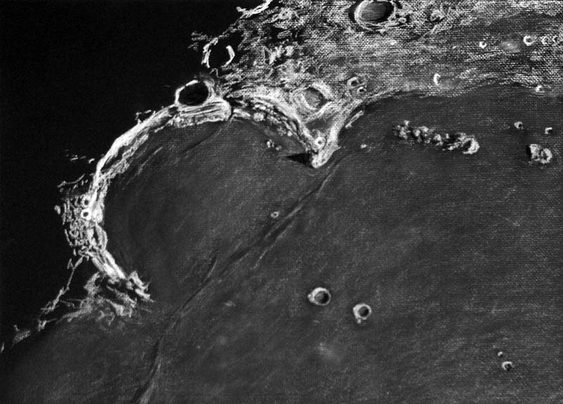
Less than a several hundred thousand years after the impact that formed the Imbrium basin about 3.8 billion years ago, the 260 km Upper Imbrian crater formed that would eventually become known to observers as Sinus Iridum, the poetically named Bay of Rainbows. In a blindingly intense blast lasting less than a couple of seconds, the roughly 13 km Iridum asteriod gouged out a section of one of the ejecta rings that surrounded the Imbrium basin, scattering a rubbly circular lens of debris around the crater. It’s floor was lower in depth to the south, where it intersected the plate shaped lowlands of the basin. Huge chuncks of ejecta covered or partially obliterated the older craters that had survived the Imbrium event, giving Nectarian aged 48 km Maupertuis on it’s northeast slopes an odd rhomboidal shape. Thirty seven km Lower Imbrium La Condamine to the north seems to have faired a little better, partially filled with Iridum ejecta. 24 km Bouguer to its west is the the most recent, of Copernician age. To the northwest it pushed up the rim creating the Jura mountains, in places 6000 meters high. Even though the Imbrium basin had been flooding for a few hundred thousand years, and the mare basalts had not yet reached the lower elevations of the southern rim of the Iridum crater, it seems likely that Iridum’s floor had already been weeping a slow flow of lava from fissures that had been opened up by the force of the fiery impact. Still it would be close to half a billion years before the Imbrium flows began to erode the southern peaks and cascade down the slopes to completely cover the crater floor. As the lower southern floor began to subside from the load of dense basalt, the whole southern rim section may have suffered a series of catastrophic slides further down into the Imbrium basin, producing the clean separation at the 2600 meter high Promontorium Laplace, the eastern cape. Now only the sinuous dorsae near the craterlet Laplace A mark the rim’s southern boundry. To the west, the Promontorium Heraclides, Cassini’s aptly named “Moon Maiden”, reaches a height of 1700 meters, yet the western cape seems to taper to the southwest, blending rather smoothly into the mare. Along with its slow liquid inundation, Iridum was struck by several small impacts, most notably 39 km Upper Imbrian Bianchini which apparently caused a section of the northern rim to collapse, creating a talus of regolith beneath it’s southern rampart as a result of the seismic shock imparted so close to the rim of Iridum. Beyond the capes to the southwest are the 26 km Imbrium aged crater Helicon and it’s smaller companion, 20 km Eratosthenian Le Verrier. Out on the mare, to the west of Promontorium Laplace, is Montes Recti, a rectangular group of mountains 94 km long x 12 km wide, at 1800 meters, towering over the surrounding somber lava plains.

Sketch details:

Subject: Sinus Iridum #14 of L100 Rukl: 2, 3, 10 , 11
Time: 4:47 UT till 6:10 UT Date: July 25, 2007
Seeing: Antoniadi III -II Weather: clear and calm
Lunation: 10.7 days
Colongitude: 35.8 deg.
Illumination: 76.8%
Lib. in Lat.: +07 deg. 31 min.
Lib. in Long.: -03 deg. 28 min.
Phase: 57.6 deg.
Telescope: 12″ Meade SCT f/10
Binoviewer: W.O. Bino-P with 1.6X nosepiece
45 deg. W.O. erect image diagonal
Eyepieces: 18mm W.O. Plossls
Magnification: 271X
Sketch Medium: White and black Conte’ crayon on black textured Strathmore paper
Sketch size: 18″ X 24″

Crater Longomontanus in Early Morning

Crater Longomontanus

Crater Longomontanus
Sketch and Details by Frank McCabe

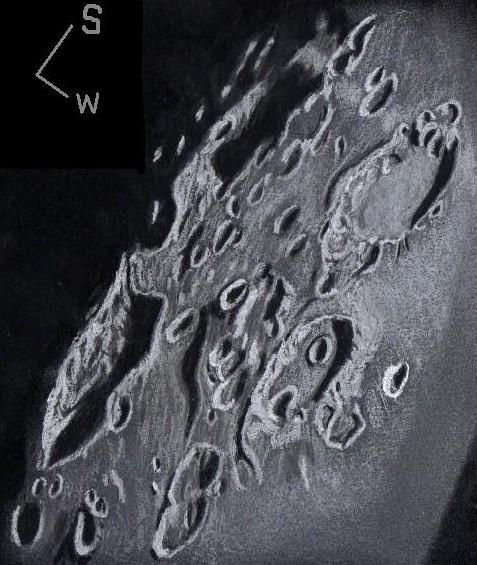
Over the past few weeks clear skies and good seeing have been absent at my usual observing site. Last evening all that changed at sundown with good clearing of the heavy cloud cover. As the moon moved eastward against the background stars and entered Capricornus, it was high enough in my sky for close examination and sketching. Among the craters of the southern highlands just at the terminator margin was walled plain crater Longomontanus (155 km. in diameter) basking in the early morning sunshine. This ancient impact is an old worn Nectarian period formation with a younger floor formed by liquefied eject from the formation of one of the distant large basins such as Orientale or Imbrium (see LPOD, December 30, 2007, C. Wood). Immediately east of Longomontanus I was able to see what remains of smaller older Longomontanus Z (95 km.). It is the darker shadowed depression that is only partly visible. The floor of this crater has small, mostly buried, central peaks which were casting long shadows on to the western inner crater wall. One of the three craters, Longomontanus L (16 km.) on the western floor stood out nicely in the grazing sunlight at the margin of the crater floor shadow to the north.

Sketching:

For this sketch I used: black Strathmore 400 Artagain paper 8”x11”, white and black Conte’ pastel pencils and a blending stump. After scanning, Brightness was decreased (-3) and contrast increased (+3) using Microsoft Office Picture Manager.

Telescope: 10 inch f/ 5.7 Dobsonian and 9 mm and 6mm eyepieces 161x, 241x
Date: 10-9-2008, 0:10 – 2:15 UT
Temperature: 10° C (50° F)
clear, calm, humid
Seeing: Antoniadi III
Colongitude: 23.4 °
Lunation: 9.7 days
Illumination: 65.9 %

Frank McCabe

More of the Southern Highlands

Southern Highlands

Lunar Southern Highlands
Sketch and Details by Frank McCabe

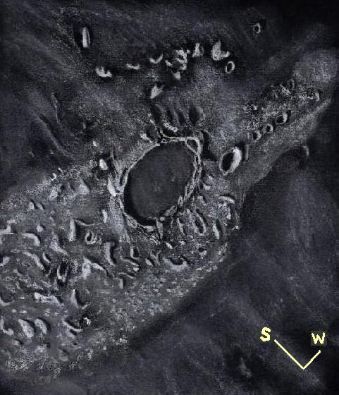
I have always found the southern highlands an interesting region of the moon to examine along the terminator. At the times of low sun the craters here take on more unique and individual identities than at higher illumination. On this observing and sketching night, I managed to examine and sketch five notable craters. From south to north along the terminator are Boguslawsky (98km.), crater Boussingault E ( 98km.) and Boussingault B (54km.). All over the southern highlands are numerous, ancient, worn, soft looking craters between 10 and 90 kilometers in diameter. Some of the craters in this region pre-date the formation of the major lunar basins. These craters look soft and dusty with smooth terraces and regolith slumping to the crater floors. Lunar geologist Donald Wilhelms speculated that the appearance of the craters here is caused mostly by fluidized ejecta and debris tumbling down the crater walls to the floor. He also believes that the craters in the region of the sketch are sitting on an ancient 650 kilometer basin that is all but destroyed save for pieces of rim here and there. The two craters further west from the terminator from south to north are Manzinus (98 km.) and Mutus (78 km.). Craters B and A, both about 16 km. in size, can be seen on the floor of Mutus.
As a target the moon proved to be a very enjoyable subject on this evening of observation and sketching.

Sketching:

For this sketch I used: black Strathmore 400 Artagain paper 10”x 8.5”, white and black Conte’ pastel pencils and a blending stump. After scanning, Brightness was decreased (-2) and contrast increased (+2) using Microsoft Office Picture Manager.

Telescope: 10 inch f/ 5.7 Dobsonian and 9 mm eyepiece 161x
Date: 9-18-2008, 4:05 – 5:30 UT
Temperature: 15° C (60° F)
clear, calm
Seeing: Antoniadi III
Colongitude 129.5 °
Lunation 18.4 days
Illumination 90 %

Frank McCabe

Crater Plato and Environs

Plato

Plato and Environs
Sketch and Details by Frank McCabe

One of the more famous features of the lunar surface is the walled plain crater Plato. This 100 kilometer crater was formed on the blocks of ejecta or the debris field (lunar Alps) of the Mare Imbrian basin forming event and it preceded the lava upwelling that flooded the floor of the crater and then the maria. Beyond the highland rise of the crater to the north is Mare Frigoris. To the west of the crater is Plato A a 22 km. crater beyond the ramparts of Plato. Just on to the smooth Imbrian lava to the south are the Teneriffe Mountains including Mount Pico at the east end of the chain. A portion of Rimae Plato was visible intermittently in among the rugged mountain bases of the Alps as seeing briefly reached average value now and again. The central peaks present at the time of the Plato impact are buried under 2 kilometer of lava and only small craterlets can be seen on the floor. Two of these were in and out of visibility as I drew this sketch. The rim on the shadowed side of the crater has irregular peaks that reach to 2.6 km. above the crater floor. At times of lower sun angles the irregular peaks cast long shadows that allow you to locate these summits.
In the years of the 17th century after the invention of the telescope, crater Plato changed names three times. In 1645 it was named Lacus Panciroli by Michael van Langren and in 1647 Johannes Hevelius named it Lacus Niger Major and finally Fr. John Baptist Riccioli in 1651 gave it the name we call it to this day.
If you have a telescope take a look at the crater floor and watch it change in brightness as we approach and then go past full moon. The moon is not light pollution it is a rewarding astronomical target.

Sketching:

For this sketch I used: black Strathmore 400 Artagain paper 10”x12”, white and black Conte’ pastel pencils and a blending stump. After scanning, Brightness was decreased (-2) and contrast increased (+2) using Microsoft Office Picture Manager.

Telescope: 10 inch f/ 5.7 Dobsonian and 9 mm eyepiece 161x
Date: 9-10-2008, 1:15 – 2:30 UT
Temperature: 15° C (60° F)
clear, calm
Seeing: Antoniadi III
Colongitude 29.6 °
Lunation 10.2 days
Illumination 72.7 %

Frank McCabe

The mysteries of Mons Rumker

Mons Rumker

Mons Rumker
Sketch and Details by Richard Handy

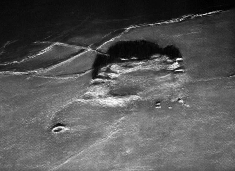
Mons Rumker sits in isolation on the dark basalts of northwest Oceanus Procellarum like a lonely sentinel on the edge of some vast undiscovered wilderness. The Rumker Hills dome complex, situated on the western flank of the Aristarchus Plateau, lies on the top of a local swelling that is about 140 km in diameter. It is composed of a remarkable set of about a dozen volcanic domes and low mounds, which are scattered in a rough semi-circular plateau approximately 70 km in diameter. The surficial domes apparently overlay preexisting low domes so that the elevated northwest sections have a pancake like appearance. Despite the long shadows when viewed close to the terminator, nowhere do these domes rise much above 500 meters in elevation from the mean surface of the mare. A central depression to the southeast of the domed crescent displays a strange dichotomy between its darker and lighter floor that is very reminiscent of areas on the Moon that have pyroclastic deposits. The mysteries of Rumker are manifold: why is this the only such layered dome field on the surface of the Moon? Why is located here? Does it predate the mare lavas or is it the representative of the last vestiges of differentiated magmas that ended the mare sequences in this area? Is the central depression part of a preexisting separate domain or were both aspects, both domes and depression deposits, created over the same period of time?

Sketch details

Subject: Mons Rumker and environs Rukl: 8
Date: 3-31-07
Session Start 8:03 UT End 9.48 UT
Seeing: Antoniadi II-III Weather clear
Lunation 1042, 12.3 days Phase: 25.2 deg Illumination 95.2%
Colongitude: 60.7 deg
Lib in Lat: +00 deg 05 min Lib. in Long: +04 deg 04 min
Telescope: Meade 12” SCT f/10
Binoviewer: W.O. Bino –P with 1.6X nosepiece
Eyepieces: 12.4 mm Meade Super Plossls
Magnification: 393X
Sketch medium: White Conte’ Crayon on black textured Strathmore paper
Sketch size: 18” x 24”

Mare Crisium

Mare Crisium

Mare Crisium
Sketch and details by Dale Holt

Mare Crisium (the “sea of crises”) is a lunar crater located in the Moon’s Crisium basin, just northeast of Mare Tranquillitatis. This basin is of the Pre-Imbrian period, 4.55 to 3.85 billion years ago. This mare is 376 miles (605 km) in diameter, and 176,000 km2 in area. It has a very flat floor, with a ring of wrinkled ridge toward its outer boundaries. Ghost craters, craters that have largely been buried under deposits of other material, are located to the south.

The crater has many notable features in and around it. The cape-like feature protruding into the southeast of the mare is Promontorium Agarum. On the western rim of the mare is the palimpsest Yerkes. The crater Picard is located just to the east of Yerkes, and northwest of Picard is the crater Peirce. Mare Anguis can be seen northeast of Mare Crisium. Mare Crisium is the site of the Luna 15 crash in 1969.

I used my 150mm F9 Triplet refractor and Denkmeier binoviewer fitted with 32mm Plossl eyepieces to view this Mare.

I captured the image on black art paper approx 125mm x 125mm using a white Conte pastel, white ‘Derwent’ watercolour pencil, white ‘Derwent’ pastel pencil, black ink pen & blending stump.

The image was scanned and reorientated hopefully to match the description above description lifted from Wikipedia.

Date of Sketch 15-Sept-2008 20.15 UT

Seeing Ant III

Mag 98x

Moon phase 99.6%

Location: Chippingdale observatory, Chipping, Hertfordshire, England

Waning Blue

Daytime Moon

Daytime Moon
Sketch and Details by Frank McCabe

23 Day Old Waning Crescent

When the moon crossed my meridian today it was more than 75° above the southern horizon. That was about one hour before I began this sketch. The last time I purchased sketching paper I bought a few sheets of light blue paper for day time lunar and planet sketching. This August has been unusual for Chicago, Illinois, in that we have had many days with cool temperatures and low humidity. Today again was one of those very transparent days although clouds were frequent and stopped me from sketching from time to time. Actual sketching time was about 45 minutes over a two hour period.

Sketching:

For this sketch I used: light blue drawing paper cut to 12’x14”, white Conte’
pastel pencils, a light blue Crayola pencil, a blending stump and my index finger too. No adjustments were need after scanning except size reduction.
Telescope: 4.25 inch f/ 5 Dobsonian and 12mm eyepiece 45x

Date: 8-24-2008 13:00-15:00 UT
Temperature: 20° C (68° F)
Partly cloudy, calm
Seeing: Antoniadi III
Colongitude: 188°
Phase: 262.9°
Lunation: 23 days
Illumination: 44 %
Libration Latitude -6°
Libration Longitude -1°

Frank McCabe

A Trio in Resplendent Isolation

Bullialdus

Bullialdus and A and B
Sketch and details by Richard Handy

Sitting in replendent isolation on the lava plains of Mare Nubium, the magnificent 61 km Bullialdus reflects the early morning sunlight strongly off the steep cliffs ringing it’s western rim. If you were to stand on this precipice next to this face, a nervous downward gaze would reveal huge islands of collapsed rubble nearly 1800 meters of almost vertical drop below you. Wrapping around in great arcs with your field of view, on the opposite side of the crater, these giant terraces would appear as tumbled foothills rising from a deep gray plain, interrupted by the brightly lit jutting central peaks of Bullialdus. The wreath of folded crust that forms the glacis of Bullialdus is one of it’s most alluring aspects. It seems replete with craggy flows of broken crustal rock arranged radially around the outer rim. As an Eratosthenian aged crater, little is preserved of this iconic crater’s once prominent ray system, but at one time it must have been quite a sight, powdery rays splayed across the long cooled Nubium flows. But time, sunlight and micrometeorites fade everything. Craters like Bullialdus are classified as complex craters. The force of the impact of the original asteriod is strong enough to distort the surface downward a few kilometers. In response to this compression, the surface rebounds almost explosively, creating extraordinay results: central peaks and rim terrace mega collapse slides. Bullialdus’s peaks are close to 1000m high. The annulus of mass wasting, especially in a couple of areas to the south west of the floor do appear to almost encroach on the central peaks. To the south of Bullialdus is Bullialdus A. There seems to be a scooped depression that connects Bullialdus to it’s diminutive neighbor, as if the shock of A’s formation created a landslide off this section of the glacis of Bullialdus. Futher to the southwest Bullialdus B echos this odd terrain.

Sketch Details:

Date: 6-25-07 Start- 4:30 UT End- 6:00 UT
or: 6-24-07 21:30 to 23:00
Lunation: 10.05 days Phase: 61.1 deg Illumination: 74.2%
Lib. in Lat.= +5 deg 56 min Lib. in Long.= -00 deg 10 min
Seiing: Antoniadi II to III Weather: clear
Telescope: 12″ SCT f/10
Bino viewer: W.O. Bino-P with 1.6X nosepiece
Eyepieces: 12.4 mm Meade Super Plossls
Magnification: 393X
Medium: White and black Conte’ Crayon on textured black Strathmore paper.
Sketch size: 18″x 24″

A Day Before Full

Schluter

Schluter, Grimaldi, and Riccioli Craters
Sketch and Details by Frank McCabe

At one day before full moon the illumination along the western terminator, nearly at the limb was highlighting the Upper-Imbrium crater Schluter (92 km.) with its central peak protruding out from the darkness of the crater floor. The outer reaches of Mare Orientale in the name of the Cordillera mountains were just beyond the sunlight at the lunar limb. The largest feature in this sketch is the lava covered, very dark floored impact basin known as Grimaldi (230 km.) What we see of Grimaldi is the inner ring of a 440 kilometer, two ringed mini-basin. This Pre-Nectarian impact event was originally described as a walled plain crater of advanced age with a heavily worn and battered rim. The basin is noted for a large gravitation anomaly beneath the surface associated with a high mass density concentration. Adjacent to Grimaldi to the west is semi-dark floored walled plain crater Riccioli (150 km.) At the same age as its eastern partner it shows damage and age especially from the ejecta pitched out by the Mare Orientale event.

Sketching:

For this sketch I used: black Strathmore 400 Artagain paper 9”x12”, white and black Conte’ pastel pencils and a blending stump. After scanning, Brightness was decreased (-5) and contrast increased (+4) using Microsoft Office Picture Manager.

Telescope: 10 inch f/ 5.7 Dobsonian and 9 mm eyepiece 161 x
Date: 8-16-2008, 3:15-4:40 UT
Temperature: 15° C (59° F)
Clear, calm
Seeing: Antoniadi III
Colongitude 85.7 °
Lunation 14.7 days
Illumination 99.4 %

Frank McCabe